The First Printed Map of Tenochtitlan
Draft: this translation has not yet been checked against the original by a separate review.
- Made
- printed at Nuremberg, March 1524; the city as Cortés's men saw it in 1519–1520
- Place
- Mexico-Tenochtitlan
- Language
- Latin (with Spanish place names)
- Kind of source
- map
- Difficulty
- Moderate
- Intensity
- Medium
MesoamericaMaps and chartsHomes, towns and buildingConquest and resistance in the Americas
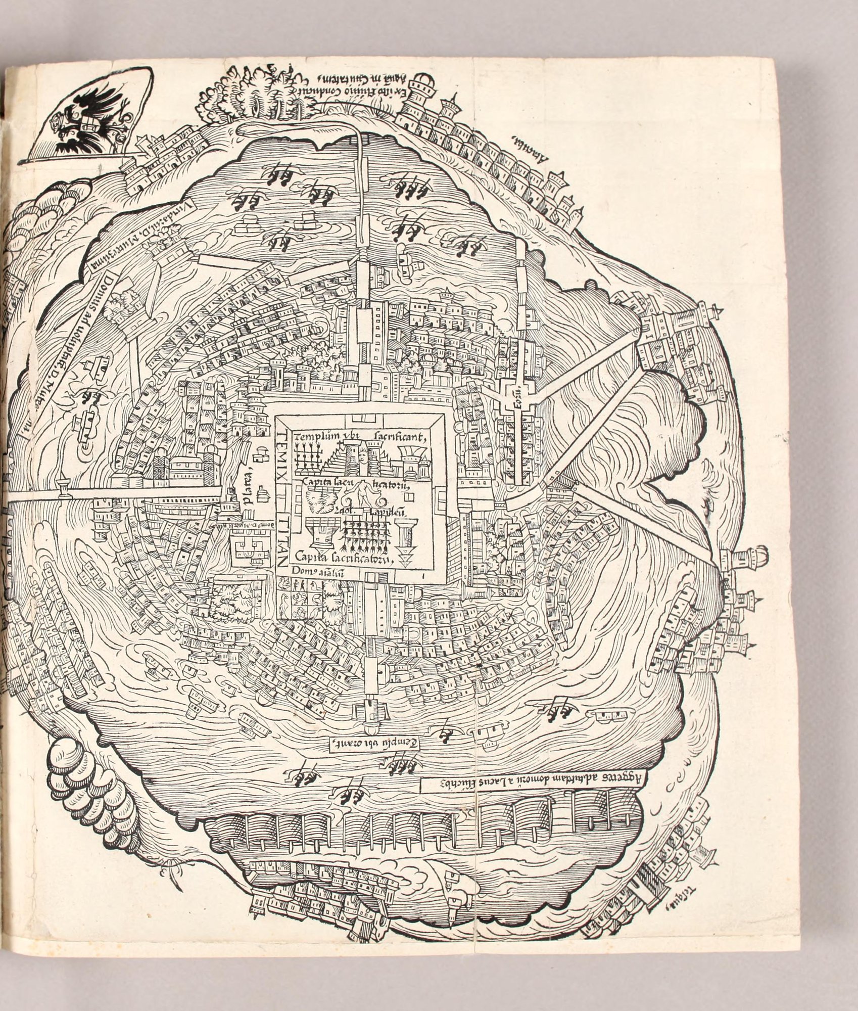
In the middle of the island city stands a walled square. Inside are a stepped temple, a statue, and racks lined with human heads, each labeled in Latin. Around it, houses crowd to the water's edge, and long causeways run out across the lake to the shore.
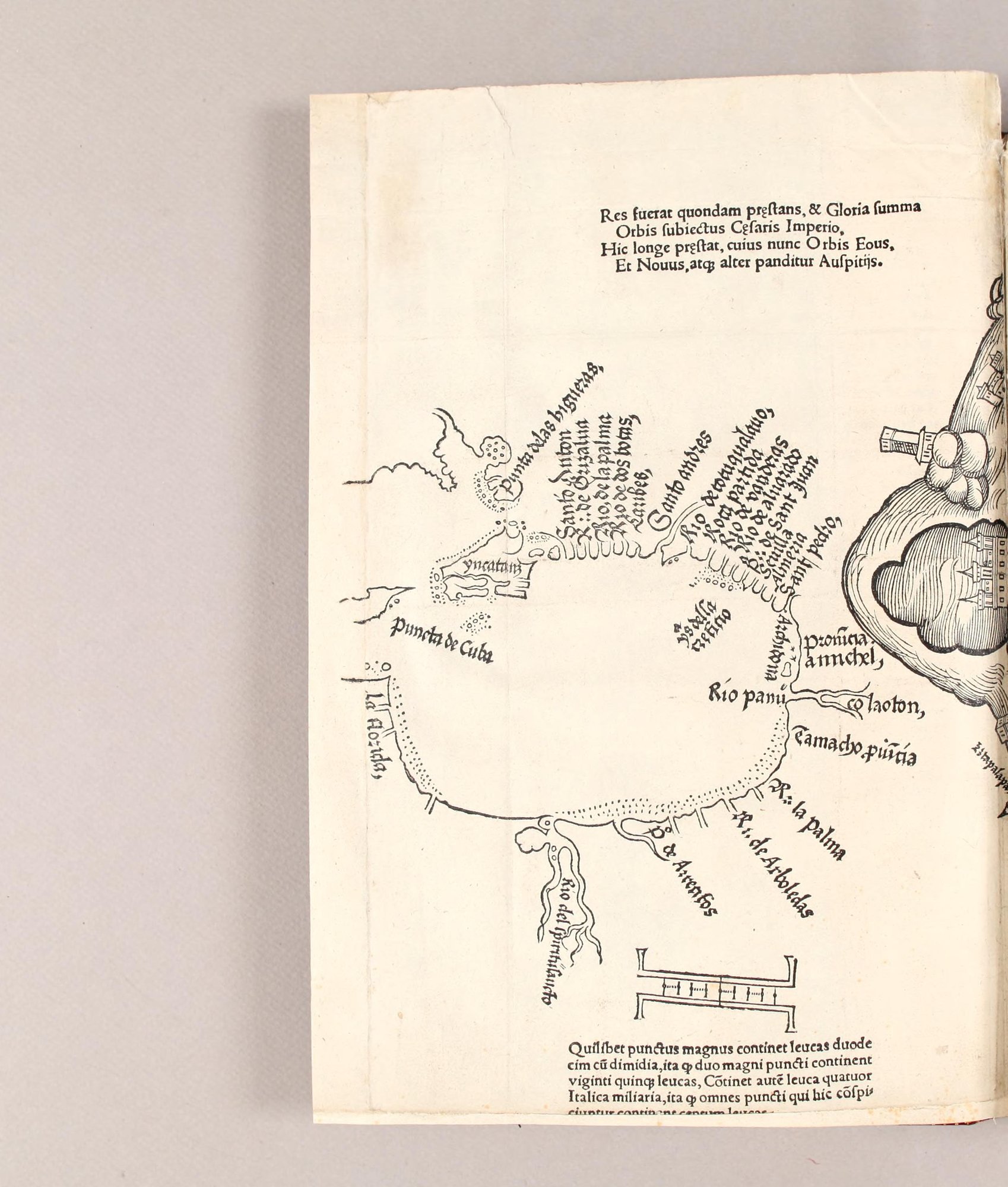
This is the first printed picture of Tenochtitlan, the Mexica capital. It was cut in wood and printed at Nuremberg, in Germany, in March 1524, as a folding plate in the Latin edition of Hernán Cortés's second letter to the emperor Charles V. Cortés wrote that letter in October 1520, after the Spaniards had been driven out of the city, and it was first printed in Spanish at Seville in 1522; Pietro Savorgnano translated it into Latin. The left half of the sheet is a map of the Gulf of Mexico, with Spanish names for the rivers and capes along the coast; the right half is the city.
No one in Nuremberg had seen the city, and who drew the plan, and from what, is not known. The houses have the look of a European town. The labels name things Cortés describes in the letter: the great temple, Moctezuma's houses and gardens, the house of animals, the water brought into the city and the causeways.
Read it as a picture made for European readers of Cortés's letter, close to his own view of the city. Watch for the labels in the temple square, and for the imperial eagle on the banner at the upper left.
The words printed on the image, in simplified modern English.
The city plan
Temixtitan1
The temple where they make sacrifices
Heads of the sacrificed
A stone idol
Heads of the sacrificed
The house of animals
The square
Lord Moctezuma's house
Lord Moctezuma's pleasure house2
Lord Moctezuma's garden
From this river, water is brought into the city.3
Tacuba4
The market square [?]
A temple where they pray
Dikes to protect the houses from the waves of the lake
Iztapalapa
The Gulf of Mexico
Once it was a great thing and the highest glory that the world was ruled by Caesar.5 This ruler far surpasses him: under his command the Eastern world, and a new and second world, now lies open.6
Each large dot stands for twelve and a half leagues, so two large dots make twenty-five leagues.7 A league is four Italian miles. So all the dots shown here make a hundred leagues.
Florida · River of the Holy Spirit · River of A[?] · River of the Groves · Palm River · the province of Tamacho · Colaoton · Pánuco River · the province of Amichel · Archidona · San Pedro · Almería · Seville · San Juan River · Alvarado River · River of Banners · Split Rock · River of [?]qualauo · San Andrés · the Caribs · River of Two Mouths · Palm River · Grijalva River · San Antón · Point of the Fig Trees · Yucatán · Point of Cuba · the island of [?]
Notes
- The Spaniards' form of Tenochtitlan, the Mexica capital on an island in the lake, on the site of present-day Mexico City. back
- Moctezuma II (Muteczuma in the Latin), ruler of the Mexica when Cortés arrived in 1519. D. stands for Dominus, “lord.” back
- The Latin is ungrammatical as printed: aquam (accusative) with the passive conducitur. The meaning is clear. back
- Atacuba is Tacuba (Tlacopan), a town on the western shore of the lake, joined to the city by a causeway. back
- The Romans' emperors. The verses praise Charles V, king of Spain and Holy Roman Emperor, to whom Cortés's letter was addressed. back
- The “Eastern world” is probably Asia, which Europeans still hoped to reach by sailing west; the “new and second world” is the Americas. back
- The league (leuca) was a measure of long distances; the note itself makes it four Italian miles. The scale is drawn with large dots. back
TEMIX TITAN
Temixtitan
Temixtitan
- The Spaniards' form of Tenochtitlan, the Mexica capital on an island in the lake, on the site of present-day Mexico City.
Templum ubi ſacrificant,
Temple where they sacrifice,
The temple where they make sacrifices
Capita ſacri ficatorū,
Heads of [the] sacrificed,
Heads of the sacrificed
Idol. Lapideū
Idol. Stone [idol]
A stone idol
Capita ſacrificatorū,
Heads of [the] sacrificed,
Heads of the sacrificed
Dom⁹ aīaliū
House of animals
The house of animals
Platea
Square
The square
dom⁹ D. Mutec[?]
House of Lord Mutec[zuma]
Lord Moctezuma's house
Domus ad uoluptatē. D. Mute[?]ma,
House for pleasure. [Of] Lord Mute[czu]ma,
Lord Moctezuma's pleasure house
- Moctezuma II (Muteczuma in the Latin), ruler of the Mexica when Cortés arrived in 1519. D. stands for Dominus, “lord.”
Viridariū. D. Muteczuma
Garden. [Of] Lord Muteczuma
Lord Moctezuma's garden
Ex iſto Flumine Conducitur Aquā in Ciuitatem,
From this river [is] conducted water into the city,
From this river, water is brought into the city.
- The Latin is ungrammatical as printed: aquam (accusative) with the passive conducitur. The meaning is clear.
Atacuba,
Atacuba,
Tacuba
- Atacuba is Tacuba (Tlacopan), a town on the western shore of the lake, joined to the city by a causeway.
Forū[?],
Market square[?],
The market square [?]
Templū ubi orant,
Temple where they pray,
A temple where they pray
Aggeres ad tutelam domorū a Lacus fluctibꝫ
Dikes for [the] protection of [the] houses from [the] lake's waves
Dikes to protect the houses from the waves of the lake
Iztapala[?]
Iztapala[pa]
Iztapalapa
Res fuerat quondam pręſtans, & Gloria ſumma
Orbis ſubiectus Cęſaris Imperio,
Hic longe pręſtat, cuius nunc Orbis Eous,
Et Nouus, atqꝫ alter panditur Auſpitijs.
It had been once an outstanding thing, and [the] highest glory, [that the] world [was] subjected to Caesar's rule. This [one] far excels, by whose auspices now the Eastern world, and [a] New and other [world], is opened.
Once it was a great thing and the highest glory that the world was ruled by Caesar. This ruler far surpasses him: under his command the Eastern world, and a new and second world, now lies open.
- The Romans' emperors. The verses praise Charles V, king of Spain and Holy Roman Emperor, to whom Cortés's letter was addressed.
- The “Eastern world” is probably Asia, which Europeans still hoped to reach by sailing west; the “new and second world” is the Americas.
Quilibet punctus magnus continet leucas duodecim cū dimidia, ita ꝙ duo magni puncti continent viginti quinqꝫ leucas, Cōtinet autē leuca quatuor Italica miliaria, ita ꝙ omnes puncti qui hic cōſpiciuntur continent centum leucas.
Each large dot contains twelve leagues with a half, so that two large dots contain twenty-five leagues. A league, moreover, contains four Italian miles, so that all the dots which are seen here contain a hundred leagues.
Each large dot stands for twelve and a half leagues, so two large dots make twenty-five leagues. A league is four Italian miles. So all the dots shown here make a hundred leagues.
- The league (leuca) was a measure of long distances; the note itself makes it four Italian miles. The scale is drawn with large dots.
La Florida, · Rio del ſpiritu ſancto · R⁰ de A[?] · R:: de Arboledas · R:: la Palma · Tamacho puīcia · co laoton, · Rio panū · Prouīcia amichel, · Archidona · Sant pedro, · Almeria · Seuilla · R:: de Sant Juan · Rio de aluarado · Rio de vanderas · Roca partida · Rio de [?]qualauo, · Santo andres · Caribes, · Rio de dos bocas, · Rio, de la palma · R:: de Grizalua · Santo Anton · Punta delas higueras, · yucatan · Puncta de Cuba · Ys della [?]
Florida, · River of the Holy Spirit · River of A[?] · River of Groves · River [of] the Palm · Tamacho province · Colaoton, · River Panu[co] · Province [of] Amichel, · Archidona · Saint Peter, · Almería · Seville · River of Saint John · River of Alvarado · River of Banners · Split Rock · River of [?]qualauo, · Saint Andrew · Caribs, · River of Two Mouths, · River of the Palm · River of Grijalva · Saint Anthony · Point of the Fig Trees, · Yucatán · Point of Cuba · Island of [?]
Florida · River of the Holy Spirit · River of A[?] · River of the Groves · Palm River · the province of Tamacho · Colaoton · Pánuco River · the province of Amichel · Archidona · San Pedro · Almería · Seville · San Juan River · Alvarado River · River of Banners · Split Rock · River of [?]qualauo · San Andrés · the Caribs · River of Two Mouths · Palm River · Grijalva River · San Antón · Point of the Fig Trees · Yucatán · Point of Cuba · the island of [?]
Who and what this source names, in the original. Each name links to every source in the library that mentions it. Not yet checked.
Ideas
- Human sacrifice Killing people as an offering to gods, or so that they would accompany the dead. Spaniards in Texas feared the sacrifices they knew of from Mexico; among the Natchez, many were expected to die with a Great Sun. Sections plan.2, plan.3, plan.5.
People
- Charles V King of Spain from 1516 and Holy Roman Emperor from 1519, to whom Cortés addressed his letters from Mexico. Latin verses on the Nuremberg map of 1524 praise him as a greater Caesar. Sections gulf.1.
- Moctezuma II Ruler of the Mexica at Tenochtitlan when Cortés arrived. The Spaniards seized him and held the city through him; he died in June 1520. Sections plan.8, plan.9, plan.10.
Places
- Cuba The largest Caribbean island, which Columbus reached on his first voyage and named Juana. Las Casas joined its conquest in 1512. Sections gulf.3.
- Iztapalapa A town on the point of land between the salt lake and the freshwater lakes south of Tenochtitlan, at the start of the southern causeway. Cortés attacked it on the day his brigantines first entered the lake in 1521. Sections plan.16.
- La Florida The Spaniards' name for the southeastern part of North America, not only the peninsula. Hernando de Soto's expedition landed there in 1539 and crossed it until 1543. Sections gulf.3.
- Mexico-Tenochtitlan The Mexica capital, built on an island in a lake in the Valley of Mexico. Cortés entered it in November 1519, was driven out in June 1520, and took it by siege in 1521; Mexico City was built on its site. Sections plan.1.
- Pánuco A river and province on the Gulf coast north of Veracruz, marked on the Nuremberg map of 1524 as Rio panū. Sections gulf.3.
- Tlacopan A town on the western shore of the lake, joined to the island city by a causeway, where the Spaniards divided their forces in 1521. Sections plan.12.
- Yucatán The peninsula of southeastern Mexico, home of the Yucatec Maya, where the Franciscan Diego de Landa lived from 1549. Sections gulf.3.
Page images of the original object or of the printed edition, from the libraries and archives that hold them. The pages shown are copied here where the holder marks them public domain; titles link to the holder's own viewer. Click a page to see it full size.
Praeclara Ferdinandi Cortesii de Nova maris Oceani Hyspania narratio (Nuremberg, 1524)
John Carter Brown Library, via the Internet Archive. scans n113–n114 (the folding map). Printed in 1524; no rights statement on the Internet Archive record.
The copy shown here, with the whole book.
New translation from the Latin labels and verses printed on the woodcut, read from the John Carter Brown Library copy. The labels are often abbreviated (domorū for domorum, Dom⁹ for Domus); the original keeps the printed abbreviations and the long s (ſ). The place names on the Gulf map are Spanish, not Latin, and are kept as printed, with a gloss in the English.
Everything legible on the sheet is included. Some names are worn or hidden in the fold of this copy and are marked [?].
- Original
- Text as printed in the named edition or on the object, read from page images. Edition: Praeclara Ferdinandi Cortesii de Nova maris Oceani Hyspania narratio, trans. Pietro Savorgnano (Nuremberg: Friedrich Peypus, March 1524), the folding woodcut map (two facing leaves). John Carter Brown Library copy (call no. 1-SIZE B524 .C827p), Internet Archive praeclaraferdina00cort, scans n113 and n114.
- Transliterated
- Not needed: the original is in the Latin alphabet
- Close English
- Close translation, kept as a working draft
- Simplified English
- Made by Hearth from the original. Not yet checked by a separate review.
- Editor’s review
- Not yet.
- Rights
- Original: public domain. Edition: public domain. Our translations and notes: CC BY-SA 4.0; credit “Hearth Library, hearthinteractive.com” with a link.
Sources for the notes
- Cortés, Hernán. Praeclara Ferdinandi Cortesii de Nova maris Oceani Hyspania narratio. Translated by Pietro Savorgnano. Nuremberg: Friedrich Peypus, 1524. John Carter Brown Library copy, Internet Archive record and scans n113–n114. https://archive.org/details/praeclaraferdina00cort
- Hearth Library. Hernán Cortés, “The Great Market of Tenochtitlan” (ea-cortes-second-letter), headnote, for the dates of the second letter.