The First Map to Name America
Draft: this translation has not yet been checked against the original by a separate review.
- Made
- 1507
- Place
- Strasbourg (?)
- Language
- Latin
- Kind of source
- map
- Difficulty
- Moderate
- Intensity
- Low
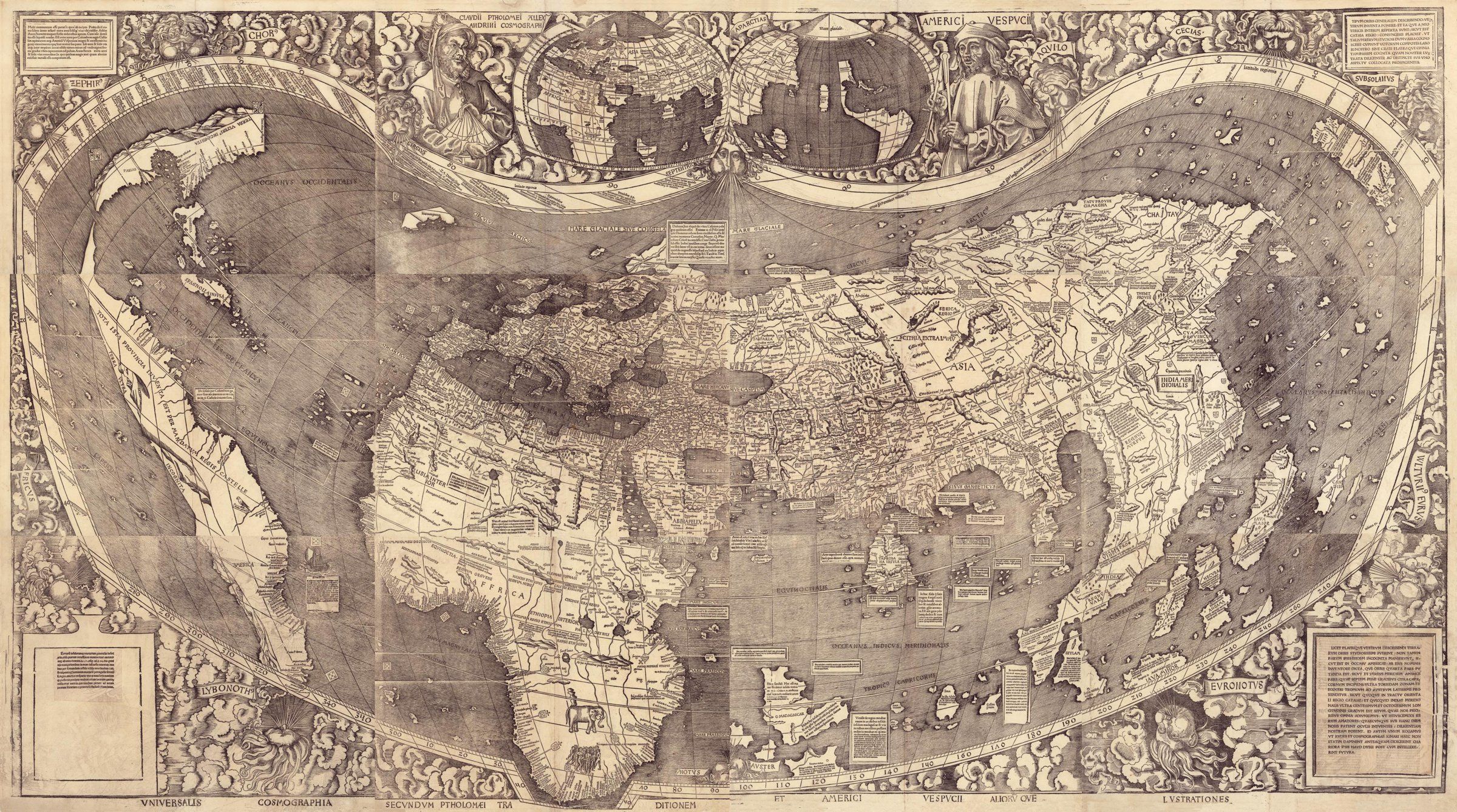
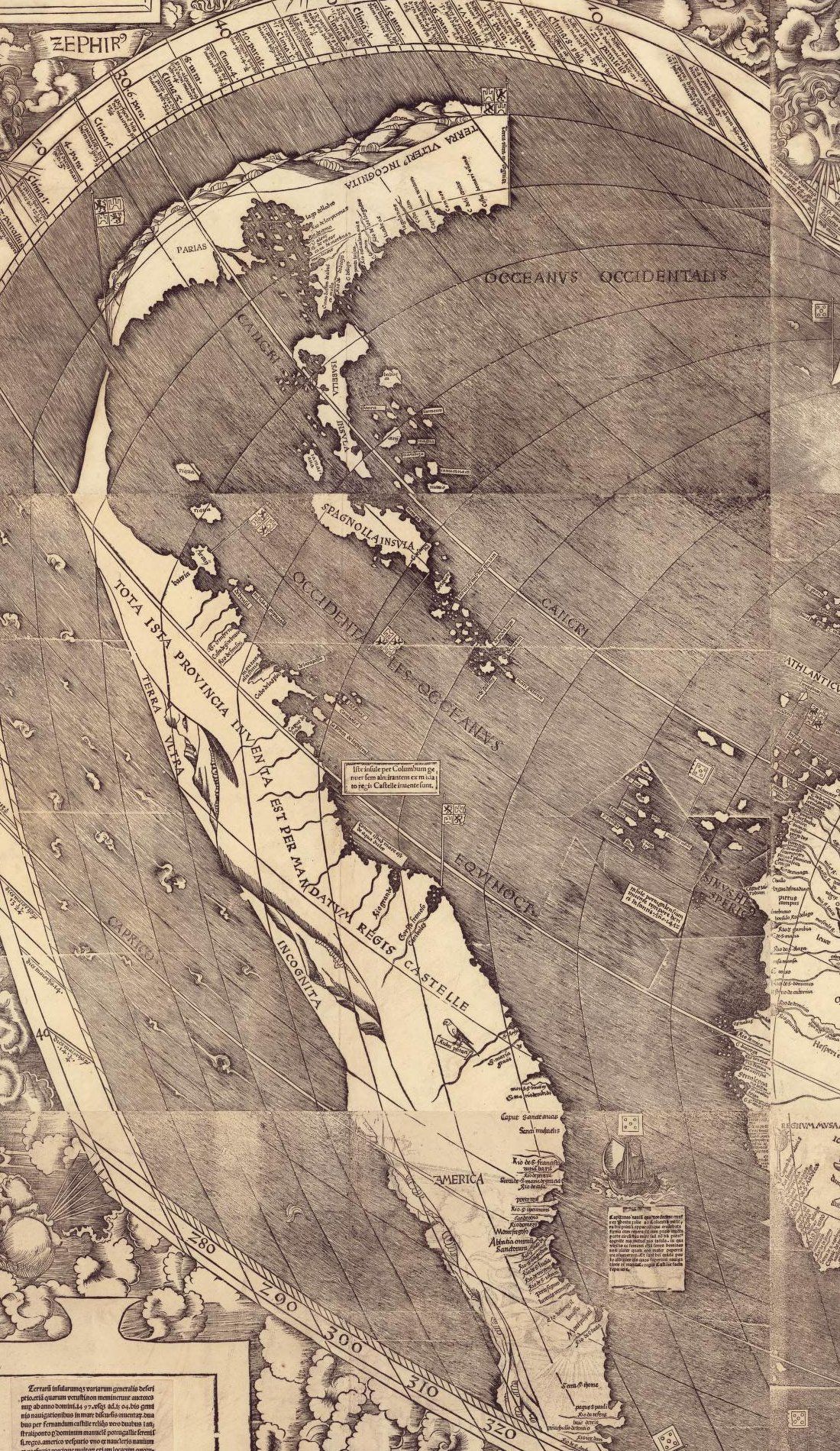
In the far south of a long, thin land in the western ocean, the woodcutter cut one word in capitals: AMERICA. It is the first time the name appears on any map, or in any document known.
Martin Waldseemüller made this world map in 1507, in twelve sheets to be pasted together. It was probably printed at Strasbourg, in about a thousand copies, and only one is known to survive. It was found bound in a volume once owned by the German map-maker Johannes Schöner, in the castle library at Wolfegg, and is now in the Library of Congress.
Its title says it follows Ptolemy, the ancient Greek geographer, and the voyages of Amerigo Vespucci and others; their portraits look down from the top. The legend at the lower left says the new lands were found between 1497 and 1504 in four voyages, two for the king of Castile and two for the king of Portugal, with Vespucci as a ship's pilot and captain.
The map was made in Europe from reports of the voyages, not by anyone who had seen the new lands. The new land is drawn as a narrow strip, and the legends mark its far side as unknown.
Watch for what the legends say was found by whom: the islands by Columbus, the mainland for the king of Castile, and the whole named for Vespucci.
The words printed on the image, in simplified modern English.
Title and portraits
A map of the whole world, following the tradition of Ptolemy and the voyages of Amerigo Vespucci and others
Claudius Ptolemy of Alexandria, geographer1
Amerigo Vespucci2
The new lands
Many people thought the famous Poet's words were a fiction, when he said that a land lies beyond the stars, beyond the paths of the year and the sun, where Atlas, who bears the sky, turns on his shoulder the heavens studded with burning stars.34 Now at last it has become clear that it is true. For a land has been found by Columbus, captain of the king of Castile, and by Amerigo Vespucci, both men of great and excellent ability.5 Most of it lies under the path of the year and the sun, between the tropics. But it still reaches about nineteen degrees beyond Capricorn toward the Antarctic pole, beyond the paths of the year and the sun.6 More gold has been found in it than any other metal.
A general description of many lands and islands, including some the ancient writers never mentioned. They were found recently, between the years 1497 and 1504, in four voyages across the sea: two sent by Ferdinand of Castile, and two more, in the southern sea, by Lord Manuel of Portugal, both most serene kings.7 Amerigo Vespucci was one of the pilots and captains of the ships. Many places are shown that no one knew of before. We have carefully added them to this picture, to give a true knowledge of the places.
On the western sheets
AMERICA
This whole province was found by order of the king of Castile
The land beyond is unknown
These islands were found by Columbus of Genoa, admiral, by order of the king of Castile.
Paria8
The land further on is unknown
The Western Ocean
Notes
- Claudius Ptolemy, a Greek astronomer and geographer of Alexandria in the second century. His Geography was the model for European world maps in Waldseemüller's time. back
- Amerigo Vespucci (1454–1512), a Florentine who sailed to the coast of South America for Spain and for Portugal, and whose printed letters described it as a new world. back
- The poet is Virgil. The lines are from the Aeneid, book 6, where Anchises foretells that Augustus will carry Rome's rule to a land beyond the stars and the sun's path. back
- Atlas, the giant of Greek myth who holds up the sky. back
- Christopher Columbus, a Genoese in the service of Castile, reached the Caribbean islands in 1492. Almirantem is his title, admiral. back
- The twelve signs of the zodiac, through which the sun moves in a year; the Tropic of Capricorn marks the sun's farthest path south. back
- Ferdinand of Aragon, who ruled Castile after Isabella's death in 1504, and Manuel I, king of Portugal from 1495. back
- Paria, the coast of what is now Venezuela, which Columbus reached in 1498. Here the name is set on the northern land. back
VNIVERSALIS COSMOGRAPHIA SECVNDVM PTHOLOMÆI TRADITIONEM ET AMERICI VESPVCII ALIORV̄QVE LVSTRATIONES
Universal cosmography according to the tradition of Ptolemy and the surveys of Americus Vespucius and others
A map of the whole world, following the tradition of Ptolemy and the voyages of Amerigo Vespucci and others
CLAVDII PTHOLOMEI ALEXANDRINI COSMOGRAPHI
Of Claudius Ptolemy of Alexandria, cosmographer
Claudius Ptolemy of Alexandria, geographer
- Claudius Ptolemy, a Greek astronomer and geographer of Alexandria in the second century. His Geography was the model for European world maps in Waldseemüller's time.
AMERICI VESPVCII
Of Americus Vespucius
Amerigo Vespucci
- Amerigo Vespucci (1454–1512), a Florentine who sailed to the coast of South America for Spain and for Portugal, and whose printed letters described it as a new world.
Multi commentum eſſe putarūt quot ab inclyto Poeta dicitᷣ extra ſidera iacere tellurē extra anni ſoliſqꝫ vias vbi cœlifer Athlas Axem humero torquet ſtellis ardentibus aptum. Cum nūc demū ita eſſe liquidū euadat. Eſt enim terra per Columbum regis Caſtiliæ capitaneum atqꝫ Americū Veſputium magni & excellentis ingenij viros inuenta/quę licet maiori ſua parte ſub anni & ſolis via atqꝫ inter tropicos iaceat nihilo tamen minus ad vndeuiginti ferme gradus vltra caprcornum ad polum Antarcticum extra anni & ſolis vias extenditur. In qua quidem magis auri quam alterius cuiuſuis metalli eſſe compertum eſt.
Many have thought [it] to be a fiction, what is said by the famous Poet, [that] beyond the stars lies a land, beyond the paths of the year and the sun, where sky-bearing Atlas turns on his shoulder the axis fitted with burning stars. Whereas now at last it turns out clearly to be so. For there is a land found by Columbus, captain of the king of Castile, and Americus Vespucius, men of great and excellent genius, which, although for the greater part it lies under the path of the year and the sun and between the tropics, nevertheless extends to nearly nineteen degrees beyond Capricorn toward the Antarctic pole, beyond the paths of the year and the sun. In which indeed more gold than of any other metal has been found to be.
Many people thought the famous Poet's words were a fiction, when he said that a land lies beyond the stars, beyond the paths of the year and the sun, where Atlas, who bears the sky, turns on his shoulder the heavens studded with burning stars. Now at last it has become clear that it is true. For a land has been found by Columbus, captain of the king of Castile, and by Amerigo Vespucci, both men of great and excellent ability. Most of it lies under the path of the year and the sun, between the tropics. But it still reaches about nineteen degrees beyond Capricorn toward the Antarctic pole, beyond the paths of the year and the sun. More gold has been found in it than any other metal.
- The poet is Virgil. The lines are from the Aeneid, book 6, where Anchises foretells that Augustus will carry Rome's rule to a land beyond the stars and the sun's path.
- Atlas, the giant of Greek myth who holds up the sky.
- Christopher Columbus, a Genoese in the service of Castile, reached the Caribbean islands in 1492. Almirantem is his title, admiral.
- The twelve signs of the zodiac, through which the sun moves in a year; the Tropic of Capricorn marks the sun's farthest path south.
Terrarū inſularumqꝫ variarum generalis deſcriptio. etiā quarum vetuſti non meminerunt auctores nup ab anno domini .1497. vſqꝫ ad .1504. bis geminis nauigationibus in mare diſcurſis inuentarꝫ. duabus per fernandum caſtille reliqs vero duabus ī auſtrali ponto p̄ dominum manuelē portugallie ſereniſſi. reges. americo veſputio vno ex naucleris nauium qꝫ prefectis precipue multoꝝ etiam locorum quoruꝫ nulla erat noticia. que nos huic picture ad veram locorum ſcientiam exprimendā ſtudioſe ꝯiunximus.
A general description of various lands and islands, even of those which the ancient authors did not mention, found lately from the year of the Lord 1497 to 1504 in twice two voyages run across the sea, two by Ferdinand of Castile, the other two in the southern sea by Lord Manuel of Portugal, most serene kings, Americus Vespucius being one of the pilots and captains of the ships, chiefly; also of many places of which there was no knowledge. These we have carefully joined to this picture, to express true knowledge of the places.
A general description of many lands and islands, including some the ancient writers never mentioned. They were found recently, between the years 1497 and 1504, in four voyages across the sea: two sent by Ferdinand of Castile, and two more, in the southern sea, by Lord Manuel of Portugal, both most serene kings. Amerigo Vespucci was one of the pilots and captains of the ships. Many places are shown that no one knew of before. We have carefully added them to this picture, to give a true knowledge of the places.
- Ferdinand of Aragon, who ruled Castile after Isabella's death in 1504, and Manuel I, king of Portugal from 1495.
AMERICA
America
AMERICA
TOTA ISTA PROVINCIA INVENTA EST PER MANDATVM REGIS CASTELLE
This whole province was found by command of the king of Castile
This whole province was found by order of the king of Castile
TERRA VLTRA INCOGNITA
Land beyond unknown
The land beyond is unknown
Iſte inſule per Columbum genuenſem almirantem ex mādato regis Caſtelle inuente ſunt.
These islands were found by Columbus the Genoese, admiral, by command of the king of Castile.
These islands were found by Columbus of Genoa, admiral, by order of the king of Castile.
PARIAS
Parias
Paria
- Paria, the coast of what is now Venezuela, which Columbus reached in 1498. Here the name is set on the northern land.
TERRA VLTERI⁹ INCOGNITA
Land further unknown
The land further on is unknown
OCCEANVS OCCIDENTALIS
Western ocean
The Western Ocean
Who and what this source names, in the original. Each name links to every source in the library that mentions it. Not yet checked.
Ideas
- Gold and silver The metals European explorers hoped above all to find in the Americas, and asked about by signs from the first meetings. Sections legend-top-left.
People
- Amerigo Vespucci A Florentine who sailed to the coast of South America for Spain and Portugal around 1500. Printed letters under his name called the lands a new world, and Waldseemüller's map of 1507 named them America after him. Sections title, vespucci, legend-top-left, legend-bottom-left.
- Christopher Columbus The Genoese navigator who sailed for Ferdinand and Isabella in 1492 and made four voyages to the Caribbean. Pané and others call him the Admiral. Sections legend-top-left, iste-insule.
- Claudius Ptolemy Greek astronomer and geographer of Alexandria in the second century CE, whose Geography was the model for European world maps around 1500. Waldseemüller's map of 1507 names him in its title. Sections title, ptolemy.
- Ferdinand II of Aragon King of Aragon who ruled Spain jointly with his wife, Isabella of Castile, and sponsored Columbus's voyages. Sections legend-bottom-left.
- Manuel I of Portugal King of Portugal from 1495, who sent the voyages to India and to the coast of Brazil that Waldseemüller's map credits to him. Sections legend-bottom-left.
- Virgil The Roman poet of the Aeneid. Petrarch kept a manuscript of his works with him most of his life and wrote of Laura's death in it. Sections legend-top-left.
Places
- America (the name) The name Waldseemüller's world map of 1507 gave the southern land found by Columbus, Vespucci and others, the first known use of the word. Sections america.
Page images of the original object or of the printed edition, from the libraries and archives that hold them. The pages shown are copied here where the holder marks them public domain; titles link to the holder's own viewer. Click a page to see it full size.
Library of Congress, Geography and Map Division (G3200 1507 .W3). No Rights Advisory; free to use and reuse.
The only known copy of the first edition, viewable sheet by sheet and as a composite.
New translation from the Latin legends printed on the map, read from the Library of Congress scans. The printers used many abbreviations (terrarū for terrarum, -qꝫ for -que) and the long s (ſ); the original keeps them as printed. Mistakes in the print, such as quot for quod and caprcornum for capricornum, are kept and noted.
Only the legends on and around the Americas are included.
- Original
- Text as printed in the named edition or on the object, read from page images. Edition: Martin Waldseemüller, Universalis cosmographia secundum Ptholomaei traditionem et Americi Vespucii aliorumque lustrationes ([Strasbourg?], 1507), woodcut world map on 12 sheets. Library of Congress, Geography and Map Division, G3200 1507 .W3, the only known surviving copy of the first edition; digital ids g3200.ct000725C (composite) and g3200.ct000725.
- Transliterated
- Not needed: the original is in the Latin alphabet
- Close English
- Close translation, kept as a working draft
- Simplified English
- Made by Hearth from the original. Not yet checked by a separate review.
- Editor’s review
- Not yet.
- Rights
- Original: public domain. Edition: public domain. Our translations and notes: CC BY-SA 4.0; credit “Hearth Library, hearthinteractive.com” with a link.
Sources for the notes
- Library of Congress, Geography and Map Division. Universalis cosmographia secundum Ptholomaei traditionem et Americi Vespucii aliorumque lustrationes, 1507. G3200 1507 .W3, LCCN 2003626426. https://www.loc.gov/item/2003626426/ (record summarized by the lead editor; images ct000725 and ct000725C).